


Search
Latest Articles
The newest essays, interviews, and features from Big Think.

Border weirdness on the Arabian peninsula

I’m on a bit of a roll here, as far as strange World War II maps are concerned. Here’s another one, again from the German side, found at this page […]

“A map of the world that does not include Utopia is not worth even glancing at”

One of the unlikeliest complexes of enclaves and exclaves in the world is to be found on the Belgian-Dutch border, and is centred on Baarle. This town, while surrounded entirely […]

Our familiarity with "gerrymandering" comes from the United States revising the boundaries of electoral districts every 10 years, in order to keep up with demographic change.

That time the ape-man found an entire Roman province in a hidden valley
A Pacific counterpart to Atlantis, Mu is supposed to have been a large continent in the middle of the ocean and the home of an advanced civilisation, having sunk beneath the […]
A British map, I presume, made between 1937 and 1940, showing the German plans for the conquest of Europe “revealed by Secret Nazi Map” – I don’t know if that […]
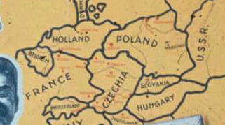
Another propaganda map dating from just before World War II, but this time from the Nazi-German side. One of the first victims of fascist agression was Czechoslovakia, dismembered at the […]
Although you probably instantly recognise its shape on a map, you may be forgiven for never having heard of Jutland. This northern European peninsula is not an independent entitiy: it’s […]

Ironically, the original name for the desert planet is Berber for 'water springs'
Post #38 of this blog showed a spoof map of the world, supposedly according to Ronald Reagan – the avuncular 40th President of the US, an icon of conservatism to some, […]
Maps on old postcards look really cool, I think (see previous post). So I looked for another one, and found this postcard, dating from 1929. Coincidentally, it illustrates another area […]
In 1849, the Mormons who had recently settled the Wild West near the Great Salt Lake, ‘proposed’ the state of Deseret. It’s not clear to me whether this ‘proposal’ equalled […]

Amikejo was located in Neutral Moresnet, a geopolitical anomaly that managed to survive for a whole century after the Congress of Vienna.
This map illustrates the ‘Totem Foods’ of North America, celebrating “the many distinctive regional food traditions on the North American continent by featuring a totem food key to the identity of […]
The application of the suffix -stan (Persian for ‘home’) generally refers to countries in central Asia – in fact, the formerly Soviet states that occupy Central Asia are sometimes referred […]

This parody map shows the world as Ronald Reagan (US president 1980-1988) might have imagined it. Even as parody, it indicates an interesting duality: on the one hand, it presents […]

A variation on post #10 in this blog, done by Alexander Cheek and to be found on this page of his website. The differences between these two maps indicate that […]